
Introduction
Recent developments in drone technology are revolutionising the way we work across a variety of industries, and one of the areas where their impact is likely to be felt the most is in agriculture. As drones become more affordable and accessible to use, the technological advances present farmers with the opportunity to gain insights across whole farms at unprecedented detail.
Coupled with increased levels of automation and other precision agricultural practices, early adopting farmers are set to benefit from the new ways of working that drones will bring. But what types of drones are most appropriate for agricultural workflows, and what kinds of information can they provide?
What different types of drones are there?
There are currently many different types of drones on the market. Aside from those sold as toys for children, high performance drones range from small lightweight models sold for hobbies, to heavy duty drones which require experience and specific qualifications to fly.
The majority of drones on the market are multi-rotor copters, which means they are powered by rotating propellors – typically 4 or more . However, fixed wing drones, which are glider shaped with a single rear propeller, do offer a popular alternative for large scale surveying since they can cover much larger areas and distances, with their reduced power requirements and therefore extended flight times.
The most common attachment for drones are standard cameras covering the visible range of light (RGB), making them popular for photography, videography and surveying. The price points can range from £100s for lightweight hobby drones such as the DJI Mini to £10,000s for larger heavy-duty drones such as the DJI Matrice.
Some of the larger drones are capable of carrying detachable payloads which allow the use of other sensors such as multi-, hyperspectral or thermal cameras, LiDAR sensors, speakers or sprayer canisters. As technology develops and the sensor systems become more compact and refined, some of these imaging sensors are being integrated into smaller drones such as the Mavic 3 Thermal and Mavic 3 Multispectral.
How are drones used in agriculture?
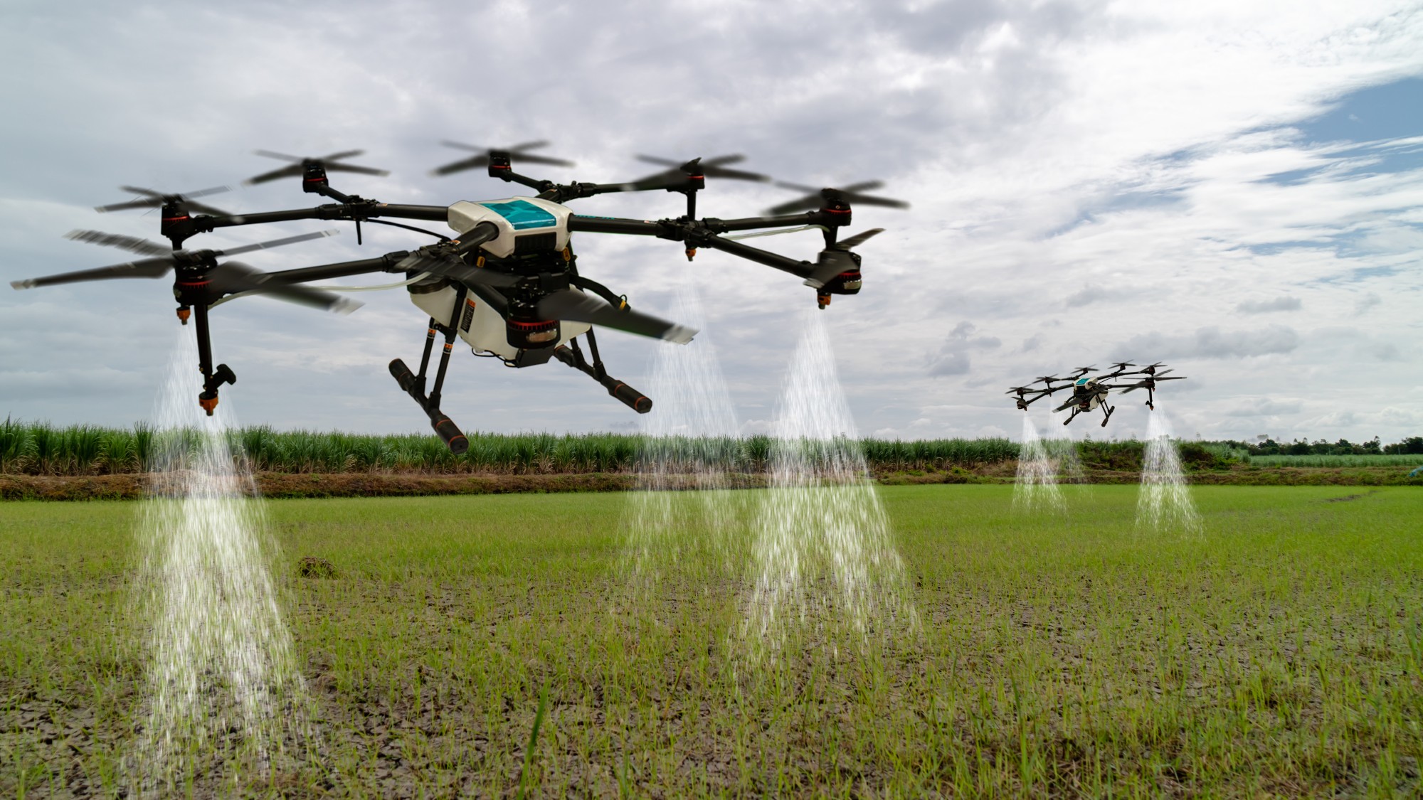
In agriculture, the main applications for drones are in surveying or spraying. Surveying drones are useful for monitoring plant emergence, counts and sizing, as well as periodic assessments of growth to aid forecasting. Spraying drones, with high payloads, can be used for precise and targeted applications of fertilisers or pesticides, but these remain rather niche, particularly in countries where safety regulations are stringent.
Surveying drone applications
The two main methods which can be used for field surveying involve scouting or photomapping. Both can help show plant variation across a field; scouting uses samples to extrapolate over a larger area, but photomapping takes images of the entire area.
Skippy scout is a fine example of scouting technology developed by Drone Ag, which uses its own flight planning software to take a bird’s eye view snapshot of a whole field from a high altitude and then flies the drone at a much lower level taking a few static images at set locations around the field. The imagery is then analysed to show statistics on crop cover, crop health, weeds, pests, and the data extracted from the imagery at these sample points is extrapolated over the rest of the field to provide a field level summary.
For this type of data collection, low specification drones such as the DJI Air can be used, since the insights are based solely off a few individual snapshots throughout the field, and this makes it more affordable and accessible for farmers to carry out this work themselves.
The alternative to this methodology of field surveying is to map the whole field, or perhaps discrete sections, as a photomap. Photomapping works by the drone operator defining a geographical area to be surveyed and the flight mapping software automatically plans a flight path to cover the area; the drones takes images at a set interval and these can then be stitched into a large orthomosaic giving a whole field photo. The drone’s altitude can be changed dependent on the resolution of imagery required, however the lower the altitude the longer the flight time but the better features of interest can be resolved.
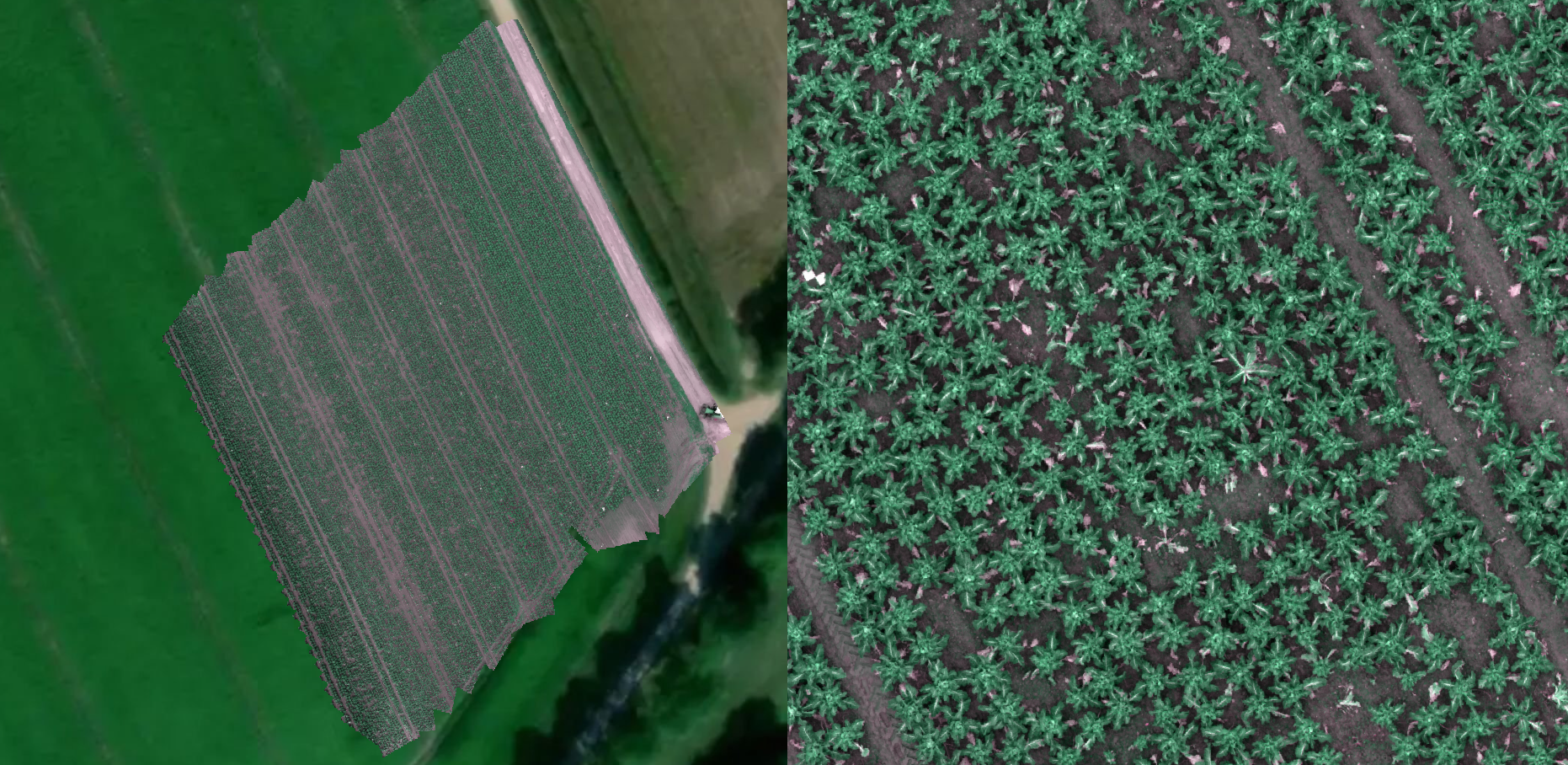
For mapping applications, it is beneficial to use a drone with RTK capabilities to improve the spatial accuracy and stitching process of the imagery. This method of surveying requires a lot more resources than scouting as more time is required at the data collection phase and there needs to be additional post processing after the images have been acquired.
RTK compatible drones, such as from the Mavic or Matrice series, tend to be more expensive than less-functional models such as the DJI Mini or Air. RTK-based photomapping also requires additional processing software, of which there are free and paid versions available. If a farmer was doing photomapping surveying on their own, they would need to be able to run their own analyses using GIS or machine learning methods, but there are companies who offer analyses on uploaded orthomosaics, such as Solvi who currently provide plant counts and sizing distributions, or Agremo who offer analyses such as weed detection, plant stress and plant vigour information.
Using either of these surveying methods can add a much higher level of visibility on a farmer’s crop, adding reassurance that things are growing well across an entire farm. However, if there are agronomic problems, such as crop damage caused by pests or disease, drones surveys can provide an early warning that is spatially resolved. Surveys can then assist in the creation of nutrient, plant health and emergence mapping, all of which can affect the volume of chemical treatments needed. This can be implemented through a sprayer drone or a precision sprayer mounted on a tractor.
What are the benefits of using drones in agriculture?
Using drones to capture aerial imagery of a field can be highly beneficial for farmers to see how the crop progresses through the season and can be effective at detecting areas where crops are failing. This gives opportunities for problems such as pests, disease or irrigation problems to be recognized and rectified. Seeing things from above gives a different perspective from what you can see on the ground and ensures that the whole field is captured.
The traditional alternative to using drones is satellite imagery. Sentinel 2 from the European Space Agency is one of the most popular services to use, since it is free to use and offers benefits like the addition of multispectral wavelengths and the revisit time of data capture is approximately only 5 days.
One downside of using Sentinel 2 is that the imagery only has 10m pixel size which subsequently affects the ability to show variation across the field. Additionally, although the revisit time is frequent, the imagery is affected by cloud cover so users can realistically go for months without usable data if the weather is particularly overcast.
Drones can overcome issues experienced by satellites since they can be flown at the altitude needed for the level of detail required. For example, a whole field overview to look at overall vegetation coverage could be flown at a high altitude of 100m, or if the purpose was to look at high level plant defects, the drone could fly much closer to the ground at 10m to distinguish individual leaves on each plant. The flexibility afforded by having end users operating drones means that data capture can be scheduled around the weather forecast so the imagery is taken on the most suitable day, and if the imagery does not come out as expected, repeat flights can be made.
What about larger drones – are spraying drones legal in the UK?
Spraying drones have made a recent appearance in the UK market, but this is still an extremely niche market, lagging behind countries such as China and the US.
Conceptually, using spraying drones in combination with a surveying drone enables farmers to adopt targeted and precision fertilizer or pesticide applications, with spraying flight plans defined by the surveying operations. This can reduce the overall amount of chemicals needed, which not only represents a cost saving, but also a significant environmental benefit. It could also reduce the amount of heavy machinery that needs to be driven through the field which will lower the amount of soil compaction and reduce the risk of crop damage.
What are the limitations of drones in agriculture?
Drone operations are under strict legislation imposed by the UK Civil Aviation Authority (CAA). The specific qualifications needed depend on the type of drone required for the intended operations. For instance, drones with a payload exceeding 2kg mandate the acquisition of a General Visual Line of Sight (GVC) qualification. Additionally, operators involved in spraying activities must obtain additional certification for the responsible use of pesticides.
Flight operations can also be limited by weather conditions. Flying with strong wind resistance requires the drone to use more power therefore reducing the amount of data the drone will be able to collect with one battery. Most drones will have their own limitations of wind and will abort a mission if it detects wind speeds reach this limit. Due to the sensitive nature of the electronics in drones, it is also not advisable to fly in rain.
Airspace limitations restrict the operation of drones in designated flight restriction zones, for example around commercial or military airports. These areas are geofenced from flying activities and drones will not follow any flight path planned in these areas. In some circumstances, it is possible to gain exemptions to fly in certain flight restriction zones, but this may require a formal NOTAM submission and would require prior permission from air traffic control and potentially communication during the flight.
This means routine flights at farms which border airports tends not to be feasible under current restrictions. Additionally, other areas can sometimes be given temporary restrictions, adding them to no-fly zones, for example if there is special military training or a large event such as a festival.
Capturing an entire field image in a single snapshot at a high altitude can be accomplished within minutes. However, when higher resolution imagery is necessary, the drone must fly at a lower altitude, requiring the capture of a series of images to form a photo map. This is time consuming and the strict Visual Line of Site (VLOS) requirements means that the operator must have continuous attention and control over the drone.
Capturing data in the form of photo map also results in large amounts of data which need to be transferred from SD card to a computer ready for processing into the orthophoto. There are a few options on the market for doing this: Pix4d, DroneDeploy, Web ODM. Most photogrammetry software requires a license to use which is another added cost, however Web ODM does offer an open-source alternative.
Emerging Drone Technology
Technology is being developed to overcome at least some of the restrictions mentioned above.
The DJI dock is an impressive piece of technology which shows how the future of drones can become autonomous. The dock is designed to be installed in a fixed location from which the drone can launch and return home to with no human intervention at the site required. The drone docks and recharges itself ready for the next flight. Flights can either be planned remotely or set up to happen routinely.
The downside of this ever-developing technology is that it requires special exemptions from the UK CAA in order to be operated as it requires Beyond Visual Line of Site (BVLOS). However the CAA has released a road map that aims at granting exemptions through a comprehensive application process, but then using this as a way to safely test how the legislation can develop to allow BVLOS to be rolled out to the wider drone community. The CAA have acknowledged that ‘it is not sustainable to operate on exemptions alone, and that a business as-usual approach is required’.
This emerging technology is highly promising for agriculture, since drones can be pre-programmed to survey each field on the farm at a regular interval to build up time series data without needing to deploy an operator regularly. This would give growers valuable insights into the crop development of their farm over the season, without the need for personnel to be in the field.
B-Hive Innovations’ use of drones
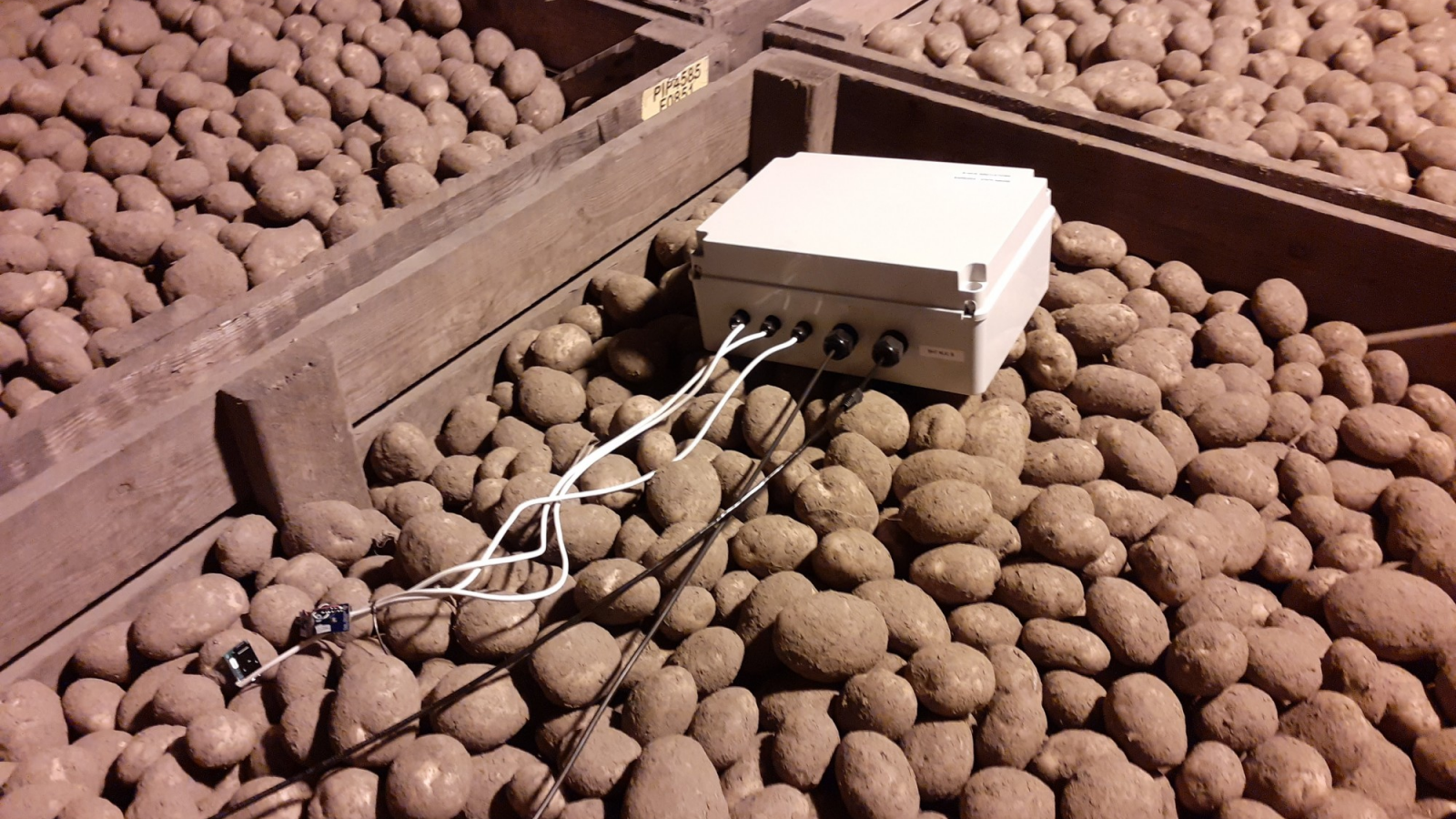
Our Tuberscan project is great example of how drones have helped us collect high resolution data efficiently. Tuberscan is an approach to forecast the sizeband development of potato growth across an entire field, while the potatoes are still underground, and in doing so to predict the optimal desiccation date to achieve the highest marketable yield possible.
Tuberscan uses ground penetrating radar to look under the ground and measure the mass of potatoes growing, but we also need information about the above-ground plant growth. Data capture with a drone has proven a very effective method of capturing large amounts of data across entire potato fields. The drone completes a photo mapping mission which can be processed into an orthophoto. Our in-house machine learning department then have different models they run on this imagery, such as plant detection algorithms. This spatial data then feeds into our yield predictions models, which alongside the ground penetrating radar, can give accurate sizeband profiles and can show how this varies across the field.
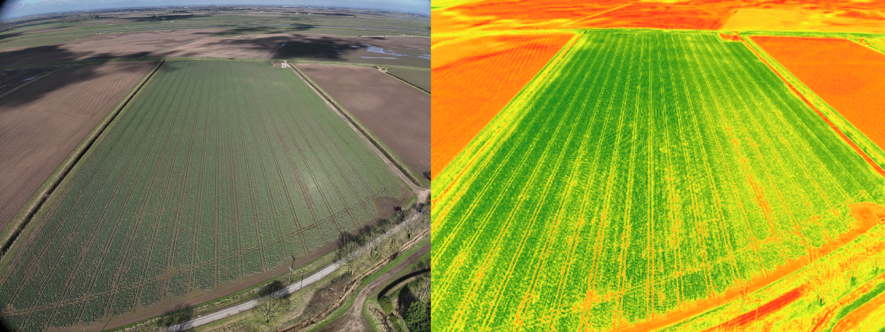
As a company, we have a variety of drone options to carry out surveying work for our research projects. For instance, the DJI Mavic 3 Multispectral which allows us to capture data using the near-infrared and red edge bands and unlocks a lot of potential for analysing crop health through indices such as NDVI, and at a much higher resolution than achievable with satellite imagery. If you are a grower / producer and want to investigate what use of a drone might do for your farming operations, we’d be pleased to chat to you, so please do reach out.
The Future of Drone Technology
Whilst agricultural drones have been growing in popularity in the past couple of decades since their launch into the UK market, it has taken a lot of product development, regulation change and mindset change to get to the point now where drone solutions can be simple enough for farmers to deploy themselves. There are many great companies, some of which have mentioned above, that have harnessed the potential of drone technology into insightful products to help aid decision making for farmers, which ultimately should save time, money or help make more environmentally conscious decisions.
Although there are many examples of how drones can play a pivotal role in crop monitoring, thereby reducing the need for physical crop walking and scouting, other emerging technologies such as autonomous vehicles are being developed at an equally rapid rate. Data from cameras mounted on autonomous vehicles would allow for similar results without the need for VLOS during data collection. However, drones currently bridge the gap of offering a comprehensive view of fields, which on-ground data capture cannot match and at a high resolution that commercially available satellite data can’t achieve.
The biggest limitations to the future of drone technology is the strict legislation which all operators must adhere to, and this means even if technology, such as the DJI Dock, continues to develop at a fast pace, there is no guarantee that this can be implemented into the UK agricultural sector. However, the CAA have committed to continue to support new developments in drone usage and simplify regulations where possible, but it is understandable that this needs to be done using a safety-first approach.
Overall, we predict that drones will play an exciting role in the future of farming alongside other developing autonomous technologies. It allows farmers to scale up data collection and make better informed decisions, which in turn should benefit not only their resources, the environment but also global food security. There is so much research, development and testing of drone products, AI data analysis and legislation that leaves the future open to vast possibilities.
The author
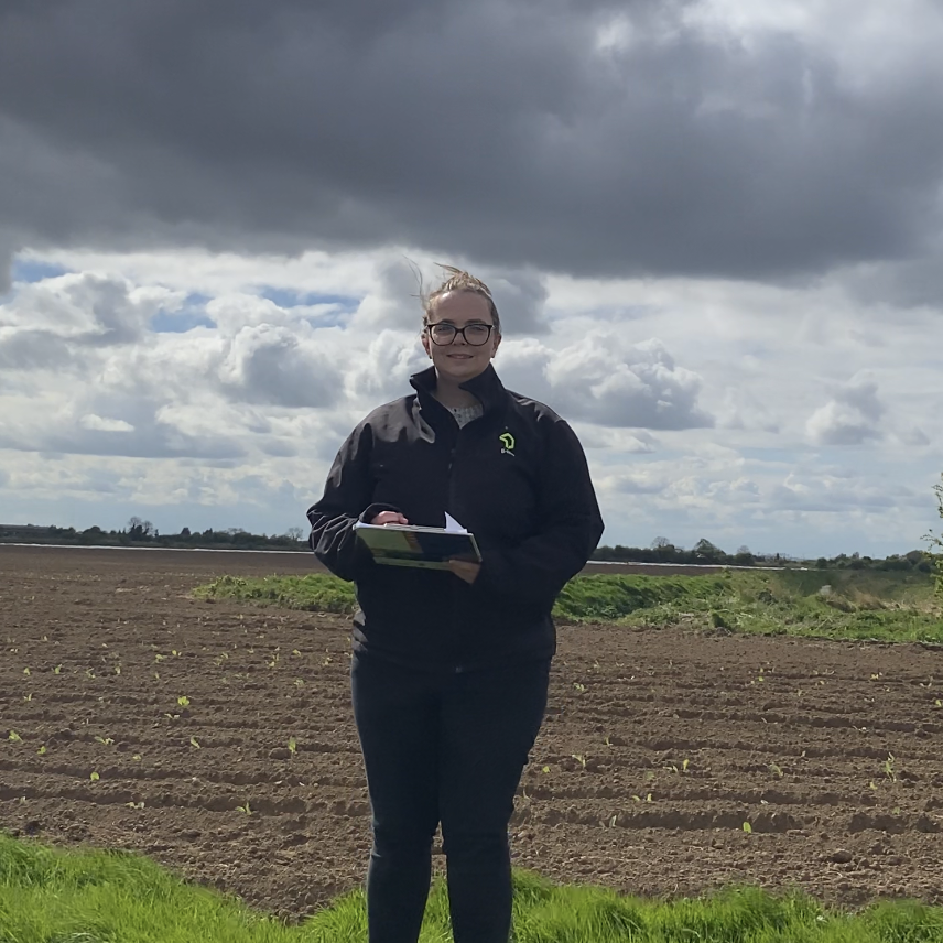
Eleanor Southwell works at B-hive Innovations as a Remote Sensing Engineer. Part of her role is to provide drone-based imaging and image processing for a range of cutting edge agritech applications.
Ellie has qualifications allowing her to fly drones of different types and weights and routinely interacts with local airfields to make drone flying possible even in no-fly zones. Ellie also has lots of experience in processing drone imagery and data to display using GIS software.